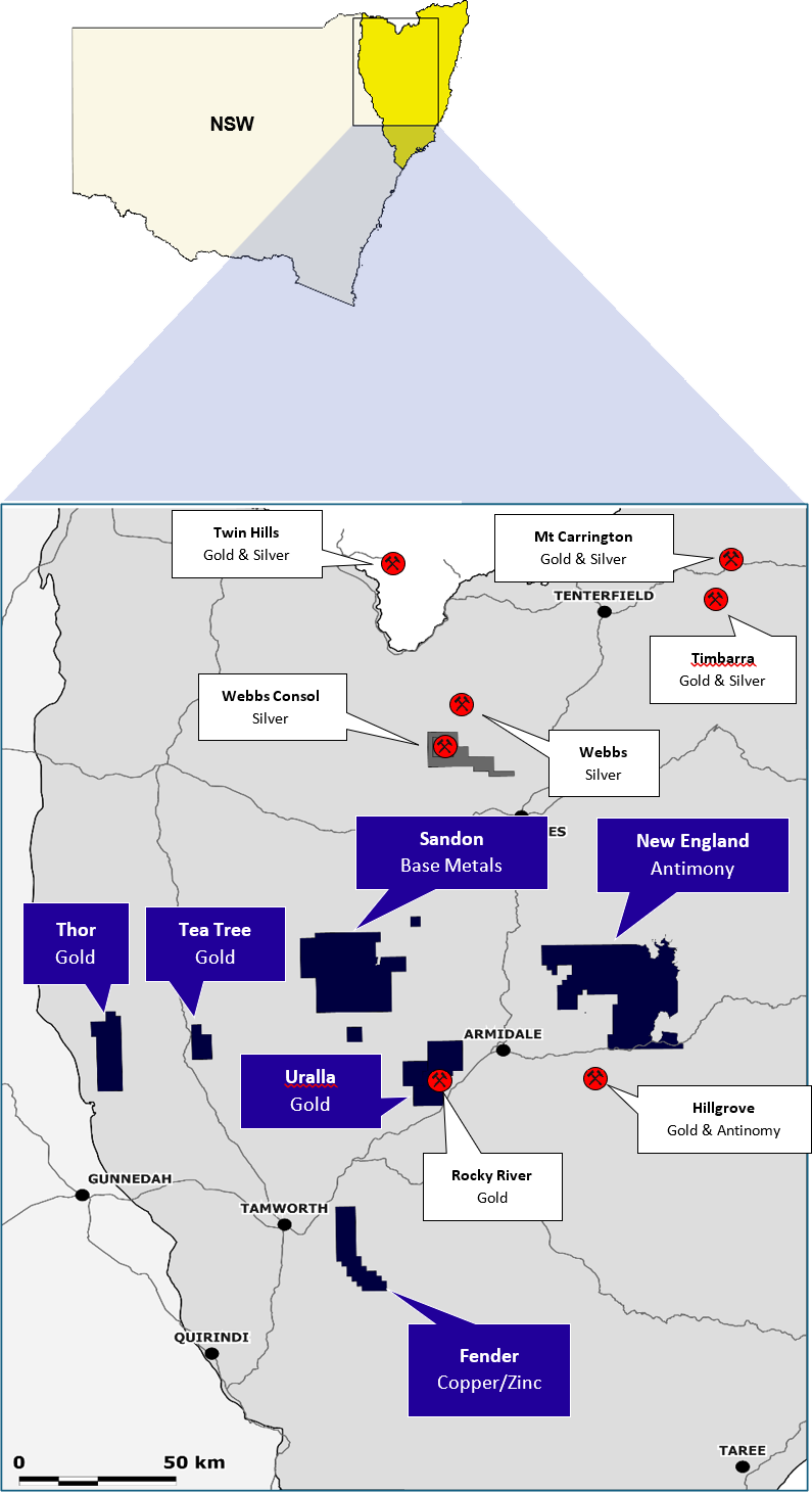
PROJECTS
Currently operating the Montezuma Silver & Antimony Project and Projects in the New England Fold Belt
With a Project selection criteria of:
1. 100% ownership 2. SIGNIFICANT EXPLORATION POTENTIAL 3. Under drilled and/or open ended mineralisation 4. Demonstrated potential for large high grade mineral occurrences
- Montezuma Silver & Antimony – High grade Silver, Antimony, Gold, Copper, Lead and Tin– Excellent drill results
- Granville Tin – Alluvial and primary tin including the Granville East Mine and Granville Tin Processing facility
- Silver Hills Silver & Antimony – Preliminary sampling and drilling is planned when this tenement is granted
- Uralla Gold – Intrusive Related Gold System (IRGS) constituting a significant gold field – Solid early drill results
- New England Antimony – Drilling at the historic Magwood antimony mine has successfully intercepted high-grade antimony mineralisation
- Trough Gully (Fender) Base Metals– High grade Zn, Cu (Au) VMS style copper deposit – Solid early drill results
- Sandon Copper – Newly added Bundarra Copper Project and Abington Base Metal Project exploration targets
- Thor Gold – Large gold anomaly potentially associated with high level intrusions or major regional fault structures
- Tea Tree Gold – Underexplored goldfield
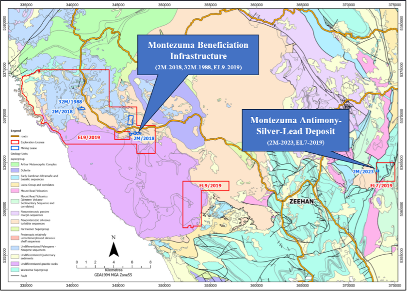
Montezuma
Near production, high-grade Antimony & Silver
Near Production
- Location: Tasmania’s West Coast mining province
- Infrastructure: Significant exisiting infrastructure with access via the Zeehan township located 14km to the west.
- History: Well known Tasmanian mining centres surround Montezuma Antimony Project including Rosebury (Zn, Pb, Cu), Renison Bell (Sn), Henty (Au), Zeehan (Pb, Ag, Sn) and Mt Lyell (Cu).
- Host Geology: Strong shearing and open space fracturing along the Montezuma Fault
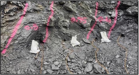
Development:
- Development of portal box cut and commencement of exploration drive has produced stockpiled mineralisation:
- Representative sampling of mined combined mineralisation / waste averaged 4.75% antimony (Sb) and 239 g/t silver (Ag)
- Representative sampling of mined mineralisation averaged 9.02% antimony (Sb) and 769 g/t silver (Ag)
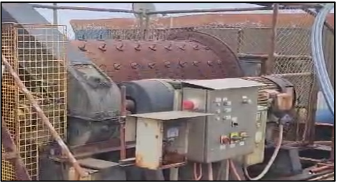
Advanced metallurgical test work:
- Metallurgical test work is well advanced with 90% recoveries of antimony achieved producing a saleable antimony product
- Off-take and R&D funding discussions are ongoing with local and international institutions including those representing major western governments
Mining & Infrastructure:
- Equipment acquired includes underground loader, excavator, bucket crusher, blast hole drilling equipment, hoppers, pumps, diamond drill rig, etc. This will provide Lode with material operational flexibility and a capital efficient pathway to progressing Montezuma
- Beneficiation infrastructure acquired includes grid power, crusher ball mill, full raw water supply dam and a recently constructed tailings dam
Exploration upside:
- The deepest drill hole to date, MZP245A, by Electrolytic Zinc Company (EZ) in 1983, after being resampled revealed a 0.63m mineralized intercept grading 11.58% Sb, 683 g/t Ag, and 25.64% Pb, demonstrating the potential continuity of mineralization at depth
- Given that mineralised lode thickness pinches and swells along strike at surface, it is also likely that this also occurs at depth, thus forming plunging shoots within the Montezuma lode structure
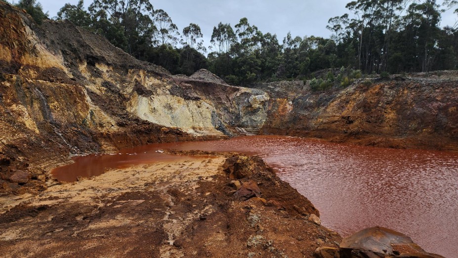
Granville Tin
High Grade Tin Hosted In Magnetite Pyrrhotite Skarns
- Location: 15km west of Zeehan, Tasmania
- Area: 92 km2
- History: Widespread alluvial tin mining in the early 1800s followed by intermittent modern mining in the 2010s with a focus on high-grade skarn tin deposits
- Host Geology: High-grade tin skarn deposits hosted by carbonaceous shales and calcareous quartzites of the Neoproterozoic Oonah Formation and associated with the Devonian-aged Heemskerk Granite
- Deposit Style: Tin bearing magnetite pyrrhotite skarns
- Processing: Yet to be determine however historical gravity separation techniques were utilised
LDR Exploration:
- Initial exploration by LDR has commenced after a review of extensive historical exploration work
- Mapping and geochemical sampling has commenced
- Detailed lithological and structural interpretations
- Several magnetic targets have been defined
- Preliminary drilling at the Granville East pit is planned
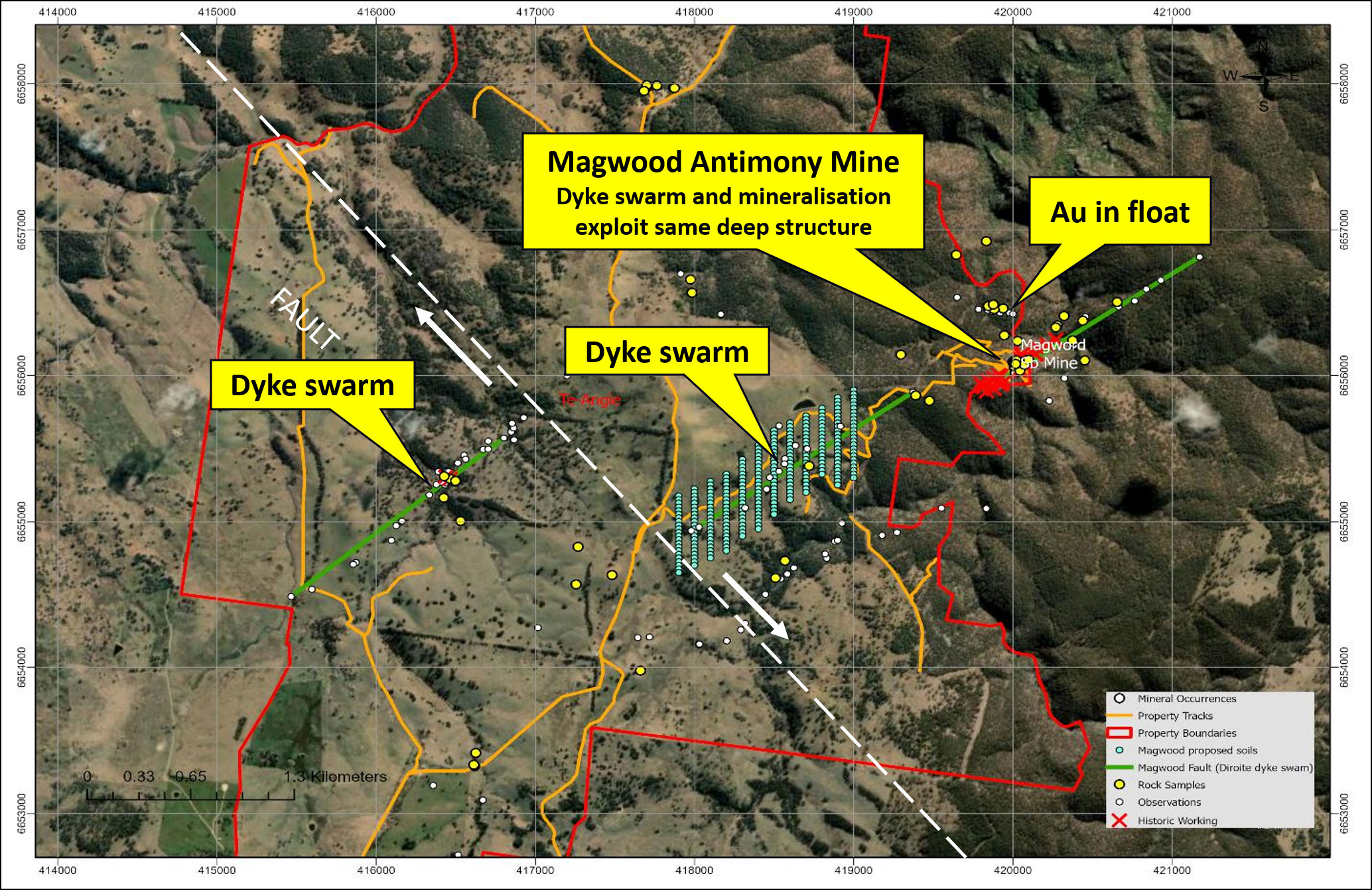
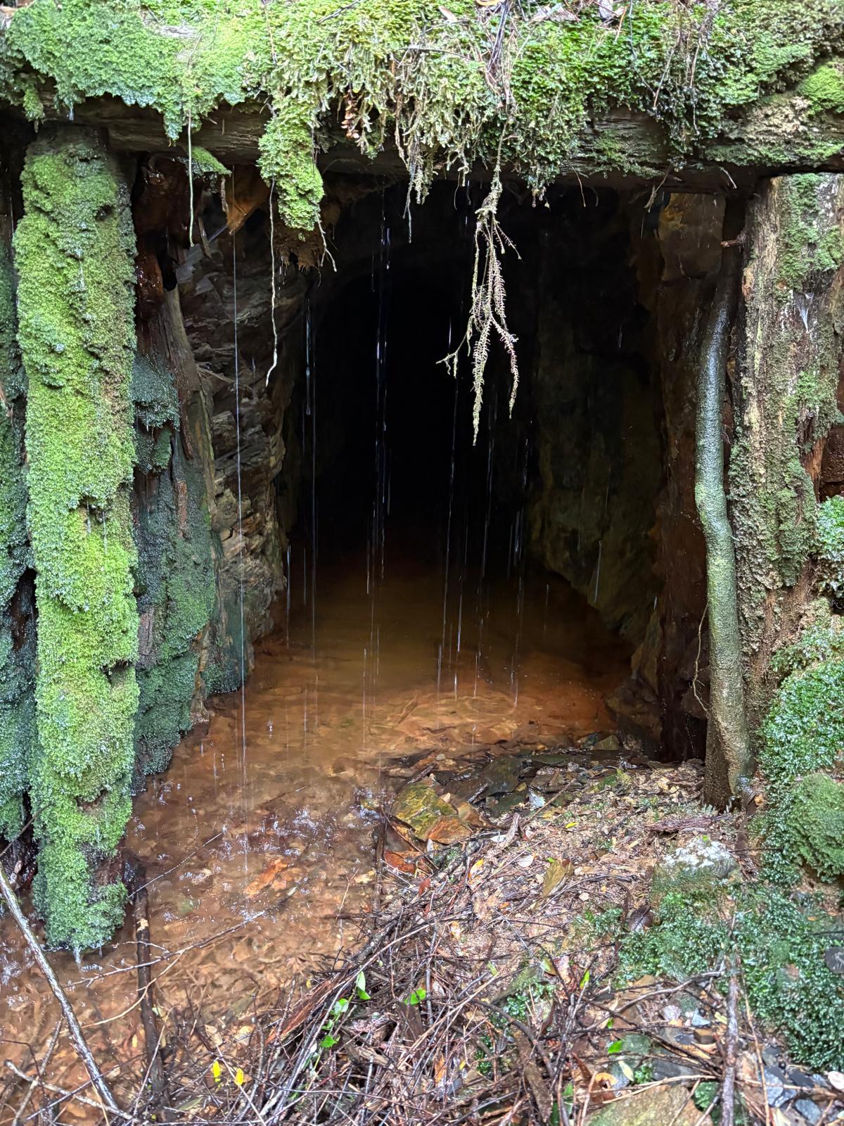
New England Antimony
High Grade Antimony Lodes
- Location: 35km north-east of Hillgrove, NSW
- Area: 1,105 km2
- History: Magwood Antimony Mine discovered in the 1880s and mainly worked between 1941 and 1970
- Host Geology: Permo-Carboniferous mineralisation hosted by Palaeozoic metasedimentary rocks, specifically interbedded mudstones and sandstones
- Deposit Style: Stibnite-quartz vein-style mineralisation hosted in NE-SW striking, steeply dipping shear zones
- Processing: Yet to be determined however historically direct shipped ore was common with some flotation carried out
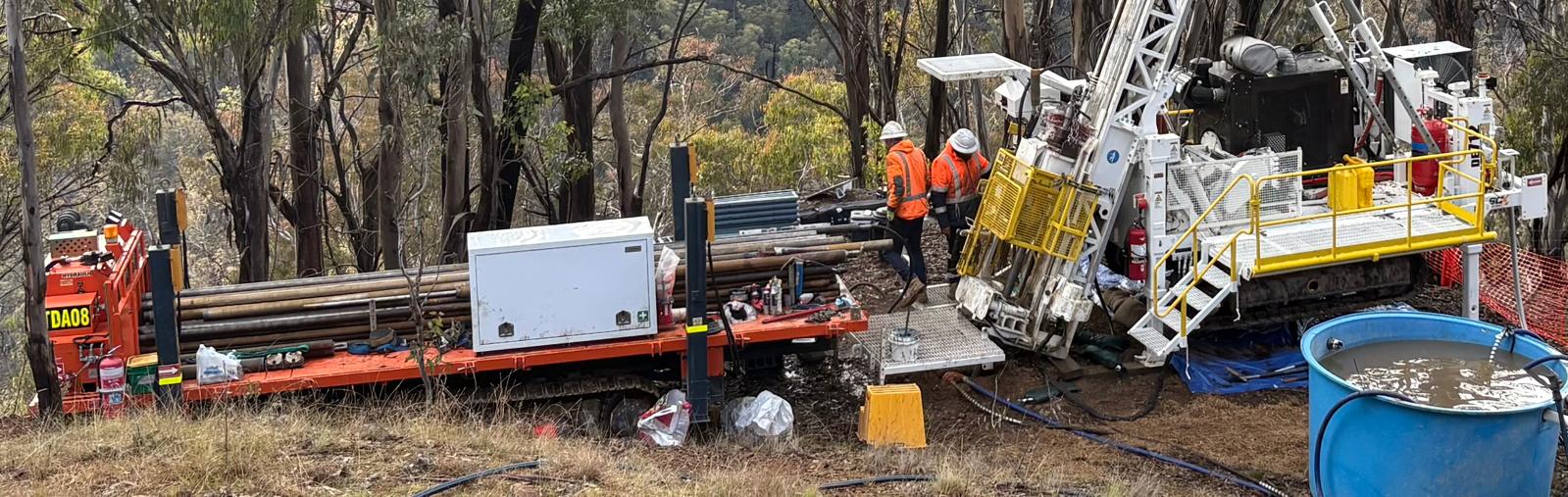
LDR Exploration:
- Inaugural drilling at the historic Magwood antimony mine has successfully intercepted remnant high-grade antimony mineralisation
- Drill core assay results up to 31.1% antimony
- Best intercept is 9.92% Sb over 4.8m in drill hole MAG010
- Extensive mapping and soil sampling defining the Magwood structure to the south-southeast for several kms
- Preliminary drilling of newly delineate targets is planned
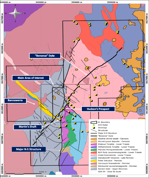
Uralla Gold
A Significant Goldfield
Drill ready
- Location: 8km west of Uralla
- Area: 302 km2
- History: One of the earlier goldfields discovered in NSW and a significant gold producer in the 1850’s.
- Host Geology: Uralla Granodiorite and other granites intrude the Sandon Beds and Wandsworth Volcanics.
- Deposit Style: Composes characteristics of a substantial Intrusive Related Gold system (IRGS).
Exploration:
- Drone Magnetics, Induced Polarisation
- Extensive mapping and geochemical sampling
- Detailed lithological and structural interpretations
- Disseminated gold mineralisation discovered through methodical field work
- Broad shallow disseminated gold intercepts in Phase I drilling at the Hudson’s Prospect including:
- KTN010: 15m @ 2.09g/t Au from 12m
- incl. 7m @ 3.65g/t Au from 15m
- incl. 4m @ 4.18g/t Au from 15m
- KTN007: 14m @ 1.24g/t Au from 68m
- incl. 2m @ 2.04g/t Au from 9m
- and 3m @ 2.21g/t Au from 77m
- KTN005: 10m @ 1.32g/t Au from 68m
- incl. 5m @ 2.49g/t Au from 9m
Silver Hills
High Grade Silver-Antimony Lodes
- Location: Waratah, Tasmania
- Area: 71 km2
- History: Silver-antimony mineralisation was first discovered and mine the area in early 1890s.
- Host Geology: Hosted within sedimentary rocks of Late Proterozoic to Early Cambrian Bischoff sedimentary sequences with mineralisation associated with intrusive igneous rocks of Devonian age.
- Deposit Style: Argentiferous antimony, galena and sphalerite within quartz-siderite lodes.
- Processing: Yet to be determined however historically direct shipped ore was common.
Exploration:
- Preliminary sampling and drilling is planned this tenement is granted.
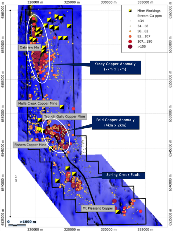
Fender
VMS Style Copper Mineralisation
- Location: 30km west of Uralla.
- Area: 223 km2
- History: Surface exploration carried out by several companies since the 1960s.
- Host Geology: Late Devonian-Early Carboniferous Myra and Sandon Beds, inter-fingered with Permian basalt, jasper and chert.
- Deposit Style: Volcanic Massive Sulphide (VMS) occurrences have been recorded over 30km strike length.
- Metallurgy: Very high recoveries in initial bulk flotation test.
Exploration:
- Stream/soil sampling, surface mapping, IP and magnetics
- Significant copper values in stream sampling over two large areas (Kasey 7km x 3km, Fold 4km x 2km). Coincides with distinct large magnetic ridges and adjacent to Spring Creek fault
- Significant copper and zinc mineralisation plus gold and silver credits in initial drilling at Trough Gully Copper Mine including:
- TGY007: 7.30m @ 9.47% ZnEq from 92.1m
- (4.93% Zn, 1.37% Cu, 0.36 g/t Au & 10.1 g/t Ag)
- TGY003: 6.90m @ 9.21% ZnEq from 50.9m
- (4.49% Zn, 1.30% Cu, 0.50g/t Au & 17.4g/t Ag)
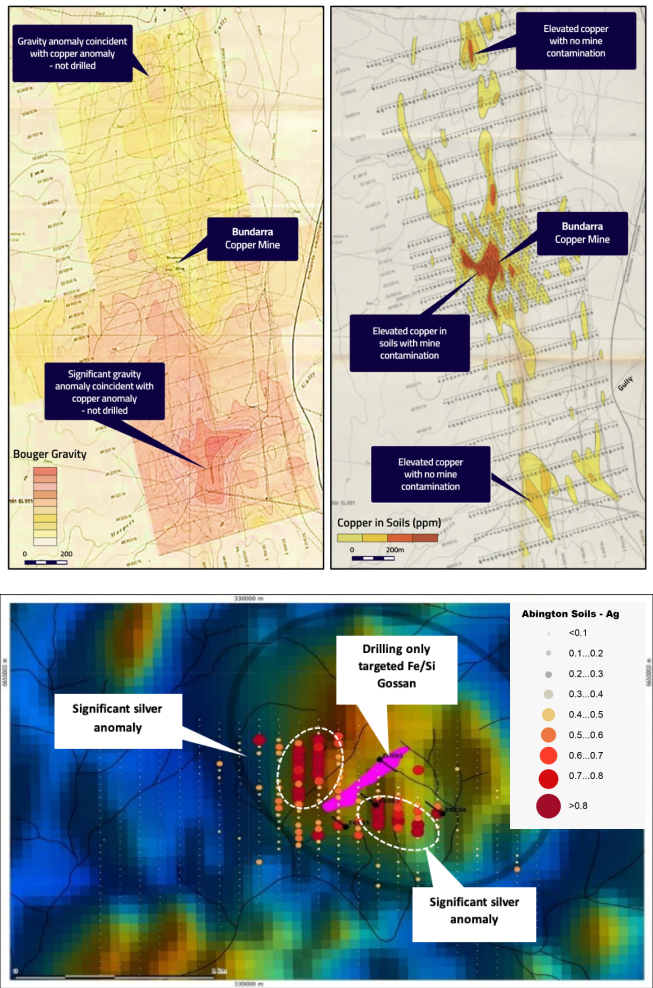
Sandon
Two Significant Targets
- Location: 5km south and 20km southeast of Bundarra.
- Area: 758 km2
- History: Surface exploration carried out by several companies since the 1970’s and some minor drilling.
- Host Geology: Carboniferous Myra and Sandon Bes, inter-fingered by Permian basalt, jasper and chert.
- Deposit Style: Volcanic Massive Sulphide (VMS)
Exploration:
- Bundarra Copper and Abington Base Metals are two prominent explorations targets
- Stream/soil, surface mapping, gravity and magnetics
- Extensive historic surface work means minimal preliminary work needed for drill target definition